Please consider helping my brother's family manage his medical needs, Thank you!

Please consider a GoFundMe donation
No Warnings, Watches, or Advisories
IMPERIAL | METRIC
Updated: Jun-16-2025 @ 12:59am   (0 sec ago)
Temperature Current Conditions Current Forecast / Storm Prediction
Currently Outside: Colder 3.3°F than last hour.

54.4°F

---
High Today
57.7°F
12:00 AM
Low Today
54.4°F
12:57 AM
Yest High
73.7°F
3:10 PM
Yest Low
55.1°F
3:57 AM
Station High*
91.7°F
2011
Station Low*
44.3°F
2020
* Today's Station Records Since 2/2009
Mostly cloudy Mostly cloudy

Calm Wind:  SSE
0.0

Gusting to:
0.0 mph
Current Rain Rain:
0.00 in
Chandler Burning Index: LOW Current CBI
Fire Danger:
-1.8 of 100
Tonight

Tonight: Mostly Cloudy then Patchy Fog
Mostly Cloudy then Patchy Fog
Monday

Monday: Patchy Fog then Mostly Sunny
Patchy Fog then Mostly Sunny
Monday
Night
Monday Night: Mostly Cloudy
Mostly Cloudy
Lo 53°F Hi 74°F Lo 55°F
SPC Activity Map
Dew Point Liquid Precipitation Wind Speed Sun/Moon
Current: Increased 31.3°F since last hour. 53.3°F
Last Hour: Increased 31.3°F since last hour. 31.3°F
High 12:00 AM: 54.5°F
Low 12:38 AM: 52.8°F
Record High: 82.8°F on
Aug-9-2024
Record Low: -18.6°F on
Feb-4-2016
Wetbulb: 53.8°F
Today: 0.00 in
Yesterday: 0.00 in
Last 7 Days: 0.41 in
Jun Rain: 3.17 in
Jun to Date
  Avg:10
2.48 in
Jun to Date
  Diff from Avg:10
Over 0.69 in for the month 0.69 in
Jun Avg: 8.05 in
Diff from Avg: Under 4.88 in for the month 4.88 in
Season:1 27.65 in
YTD
  Avg:11
25.20 in
YTD
  Diff from Avg:11
Over 2.45 in for the year 2.45 in
Last Rain
Time/Date:
Jun-14-2025
at 1:02 PM
82 rain days in 2025
7 days in June
1 day since last rain
Southern New England
Storm Totals
Storm Reports
Current: SSE  0.0 mph
1Hr Average: Calm
Wind Run: 0.00 miles
Wind Gust
Current: 0.0 mph
Today: 0.0 mph 9:00 AM
Month: 28.1 mph Jun-1
Year: 48.2 mph Mar-7
Record Gust: 55.0 mph
Feb-25-2019
Sunlight:
15 h 14 m 41 s
of Sunlight Yesterday
15 h 15 m 0 s
of Sunlight Today
Which is 19 sec longer than
yesterday
(Noon ?>) graph (Midnight

Waning Gibbous
Waning Gibbous, 20 days, 1 hours, 57 minutes in cycle
76%
Illuminated
Humidity Barometer
Current: Increased 9% since last hour. 96%
Last Hour: Increased 9% since last hour. 9%
High 12:56 AM: 97%
Low 12:00 AM: 89%
Record High: 100%
Jul-12-2017
Record Low: 0%
May-24-2024
Current: No Change 30.209 inHg
Last Hour: Steady
High 12:00 AM: 30.209
Low 12:00 AM: 30.209
Record High: 33.091 inHg
Aug-15-2019
Record Low: 25.567 inHg
Dec-16-2023
Heating Degree Days Snow3 Wind Chill Air
Today: 0.3
Jun: 37.9
2025 to Date: 3420.7
Cooling Degree Days
2025 to Date: 49.9
Today: 0.00 in
Yesterday: 0.00 in
Jun Snow: No Change 0.00 in
Jun Avg: 0.00 in
Diff from Avg: 0.00 in
Season Total:2 20.35 in
Snow Depth: 0.00 in
0 snow days in June
12 snow days in 2025.
Average 1st Snow:
0
Current: 54.4°F
Low 12:57 AM: 54.4°F
Yesterday: 55.1°F
Record: -30.8°F
Feb-14-2016
Quality
Index6:

26


Good


Density:
1.24 kg/m3
UV Summary/Forecast Solar Summary
Jun-16

8.8
Jun-17

9.1
Jun-18

8.8
Sunrise is at: 5:07
Solar Noon: val_s
Sunset is at: 20:21
Almanac Get Your Weather Banner Station All Time Records Cloud Level
Currently: Night
YTD Avg Temp: 43.5°F
Sunrise: 5:07
Sunset: 20:21
Moonrise: 23:50
Moonset: 10:11
Full Moon: Jun-10-2025
New Moon: 19:53 UTC
Jun-25-2025
HIGHS: LOWS:
103.3°F
Jul-22-2011
-13.2°F
Feb-24-2015
Daytime Records
  96.1°F°F
Jul-06-2010
  1.9°F°F
Jan-21-2019
Nitetime Records
  81.7°F°F
Jul-20-2013
  -6.2°F°F
Feb-04-2023
ICN:13 | S3C2:1 | Ajax 3.xx
ISS:Ok |
1 Rain season: Jan 1st to Dec 31st.   2 Snow season July 1st to June 30th.   3 Snow manually measured.   6 Air Quality Index is updated hourly between the hours of 6AM and Midnight.   10 Historical average only to day 16 of just the month of June for this station since 2010.   11 Historical average rain this season to day 16 of June for this station since 2010.
 NWS Weather Forecast  -   Outlook Tonight & Monday
Tonight

Tonight: Mostly Cloudy then Patchy Fog
Mostly Cloudy then Patchy Fog

Lo 53°F
NWS forecast: Patchy fog after 2am. Mostly cloudy, with a low around 53. East wind around 3 mph.
Monday

Monday: Patchy Fog then Mostly Sunny
Patchy Fog then Mostly Sunny

Hi 74°F
NWS forecast: Patchy fog before 8am. Mostly sunny, with a high near 74. East wind around 5 mph.
 NWS Short Term Weather Forecast
Monday
Night
Monday Night: Mostly Cloudy
Mostly Cloudy
Tuesday

Tuesday: Mostly Cloudy then Slight Chance Rain Showers
Mostly Cloudy then Slight Chance Rain Showers
Tuesday
Night
Tuesday Night: Chance Rain Showers
Chance Rain Showers
Wednesday

Wednesday: Chance Rain Showers then Slight Chance Showers And Thunderstorms
Chance Rain Showers then Slight Chance Showers And T-Storms
Wednesday
Night
Wednesday Night: Mostly Cloudy
Mostly Cloudy
Juneteenth

Juneteenth: Mostly Sunny then Slight Chance Showers And Thunderstorms
Mostly Sunny then Slight Chance Showers And T-Storms
Thursday
Night
Thursday Night: Chance Showers And Thunderstorms then Slight Chance Showers And Thunderstorms
Chance Showers And T-Storms then Slight Chance Showers And T-Storms
Lo 55°F Hi 74°F Lo 62°F Hi 83°F Lo 67°F Hi 90°F Lo 66°F
ajax-dashboard6.php - Version 6.95h - 20-Feb-2023 - Script by: Scott of BurnsvilleWeatherLIVE.com
Now supported by Saratoga-weather.org Download

Snowfall Forecast

Snow Total Forecast provided by the National Weather Service
NWS Northeast Regional Radar WU North East Satellite
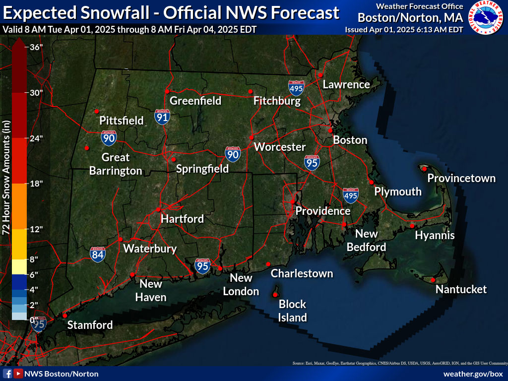
Radar/Satellite images courtesy of NOAA/NWS and Weather Underground.
spacer
Recent Graphs from the Station          (Click on the graph to view)
24 Hour 48 Hour 72 Hour 7 Days