


Tropical Cyclone Activity
Current Atlantic Satellite Loop

Current Atlantic Satellite Image
Current Atlantic Satellite Image

Atlantic/Gulf of Mexico/Caribbean
Atlantic Tropical Weather Outlook
996 ABNT20 KNHC 160501TWOAT Tropical Weather OutlookNWS National Hurricane Center Miami FL200 AM EDT Mon Jun 16 2025For the North Atlantic...Caribbean Sea and the Gulf of America:Tropical cyclone formation is not expected during the next 7 days.$$Forecaster Jelsema/Cangialosi
There are no tropical cyclones at this time.
No tropical cyclones as of Mon, 16 Jun 2025 10:20:09 GMT
Atlantic Tropical Weather Outlook
996
ABNT20 KNHC 160501
TWOAT

Tropical Weather Outlook
NWS National Hurricane Center Miami FL
200 AM EDT Mon Jun 16 2025

For the North Atlantic...Caribbean Sea and the Gulf of America:

Tropical cyclone formation is not expected during the next 7 days.

$$
Forecaster Jelsema/Cangialosi
There are no tropical cyclones at this time.
No tropical cyclones as of Mon, 16 Jun 2025 10:20:09 GMT
Eastern Pacific
Eastern North Pacific Tropical Weather Outlook
ABPZ20 KNHC 160503
TWOEP

Tropical Weather Outlook
NWS National Hurricane Center Miami FL
1100 PM PDT Sun Jun 15 2025

For the eastern and central North Pacific east of 180 longitude:

Active Systems:
The National Hurricane Center has issued the last advisory on
Post-Tropical Cyclone Dalila, located in the eastern Pacific basin
a few hundred miles west of the coast of southwestern Mexico.

Offshore of Central America and Southeastern Mexico (EP94):
A broad area of low pressure continues to produce disorganized
showers and thunderstorms over and offshore of Central America.
Environmental conditions appear conducive for gradual development of
this system, and a tropical depression is likely to form in a couple
of days while it moves west-northwestward near the coasts of El
Salvador, Guatemala, and southeastern Mexico. Interests in these
locations should monitor the progress of this system. Regardless of
development, areas of heavy rain are likely across portions of
Central America and southeastern Mexico during the next few days.
* Formation chance through 48 hours...high...70 percent.
* Formation chance through 7 days...high...80 percent.

$$
Forecaster Jelsema/Cangialosi]]>
Summary for Post-Tropical Cyclone Dalila (EP4/EP042025)
...DALILA BECOMES POST-TROPICAL... ...THIS IS THE LAST NHC ADVISORY ON DALILA... As of 8:00 PM MST Sun Jun 15 the center of Dalila was located near 18.6, -109.2 with movement WNW at 9 mph. The minimum central pressure was 1004 mb with maximum sustained winds of about 35 mph.
Post-Tropical Cyclone Dalila Public Advisory Number 14
Issued at 800 PM MST Sun Jun 15 2025 522
WTPZ34 KNHC 160233
TCPEP4

BULLETIN
Post-Tropical Cyclone Dalila Advisory Number  14
NWS National Hurricane Center Miami FL       EP042025
800 PM MST Sun Jun 15 2025

...DALILA BECOMES POST-TROPICAL...
...THIS IS THE LAST NHC ADVISORY ON DALILA...


SUMMARY OF 800 PM MST...0300 UTC...INFORMATION
----------------------------------------------
LOCATION...18.6N 109.2W
ABOUT 320 MI...515 KM W OF MANZANILLO MEXICO
MAXIMUM SUSTAINED WINDS...35 MPH...55 KM/H
PRESENT MOVEMENT...WNW OR 285 DEGREES AT 9 MPH...15 KM/H
MINIMUM CENTRAL PRESSURE...1004 MB...29.65 INCHES


WATCHES AND WARNINGS
--------------------
There are no coastal watches or warnings in effect.


DISCUSSION AND OUTLOOK
----------------------
At 800 PM MST (0300 UTC), the center of Post-Tropical Cyclone Dalila
was located near latitude 18.6 North, longitude 109.2 West. The
post-tropical cyclone is moving toward the west-northwest near 9 mph
(15 km/h). A gradual turn towards the west is expected tonight,
followed by continued westward motion for another day or two.

Maximum sustained winds have decreased to near 35 mph (55 km/h) with
higher gusts. Continued slow weakening is expected during the next
couple of days. Dalila is forecast to dissipate late Tuesday or
early Wednesday.

The estimated minimum central pressure is 1004 mb (29.65 inches).


HAZARDS AFFECTING LAND
----------------------
SURF: Swells generated by Tropical Storm Dalila will affect portions
of the coast of southwestern Mexico today. These swells are likely
to cause life-threatening surf and rip current conditions. Please
consult products from your local weather office.


NEXT ADVISORY
-------------
This is the last public advisory issued by the National Hurricane
Center on Dalila. For additional information on the remnant low
please see High Seas Forecasts issued by the National Weather
Service, under AWIPS header NFDHSFEPI, WMO header FZPN02 KWBC, and
on the web at ocean.weather.gov/shtml/NFDHSFEPI.php


$$
Forecaster D. Zelinsky
]]>
Post-Tropical Cyclone Dalila Forecast Advisory Number 14
Issued at 0300 UTC MON JUN 16 2025 521
WTPZ24 KNHC 160233
TCMEP4

POST-TROPICAL CYCLONE DALILA FORECAST/ADVISORY NUMBER  14
NWS NATIONAL HURRICANE CENTER MIAMI FL       EP042025
0300 UTC MON JUN 16 2025

POST-TROPICAL CYCLONE CENTER LOCATED NEAR 18.6N 109.2W AT 16/0300Z
POSITION ACCURATE WITHIN  30 NM

PRESENT MOVEMENT TOWARD THE WEST-NORTHWEST OR 285 DEGREES AT   8 KT

ESTIMATED MINIMUM CENTRAL PRESSURE 1004 MB
MAX SUSTAINED WINDS  30 KT WITH GUSTS TO  40 KT.
4 M SEAS.... 90NE  45SE  45SW  75NW.
WINDS AND SEAS VARY GREATLY IN EACH QUADRANT.  RADII IN NAUTICAL
MILES ARE THE LARGEST RADII EXPECTED ANYWHERE IN THAT QUADRANT.

REPEAT...CENTER LOCATED NEAR 18.6N 109.2W AT 16/0300Z
AT 16/0000Z CENTER WAS LOCATED NEAR 18.5N 108.8W

FORECAST VALID 16/1200Z 18.7N 110.5W...POST-TROP/REMNT LOW
MAX WIND  30 KT...GUSTS  40 KT.

FORECAST VALID 17/0000Z 18.8N 112.0W...POST-TROP/REMNT LOW
MAX WIND  25 KT...GUSTS  35 KT.

FORECAST VALID 17/1200Z 18.9N 113.8W...POST-TROP/REMNT LOW
MAX WIND  20 KT...GUSTS  30 KT.

FORECAST VALID 18/0000Z 18.5N 116.1W...POST-TROP/REMNT LOW
MAX WIND  20 KT...GUSTS  30 KT.

FORECAST VALID 18/1200Z...DISSIPATED

REQUEST FOR 3 HOURLY SHIP REPORTS WITHIN 300 MILES OF 18.6N 109.2W

THIS IS THE LAST FORECAST/ADVISORY ISSUED BY THE NATIONAL HURRICANE
CENTER ON DALILA. FOR ADDITIONAL INFORMATION ON THE REMNANT LOW
PLEASE SEE HIGH SEAS FORECASTS ISSUED BY THE NATIONAL WEATHER
SERVICE...UNDER AWIPS HEADER NFDHSFEPI AND WMO HEADER FZPN02 KWBC.


$$
FORECASTER D. ZELINSKY
]]>
Post-Tropical Cyclone Dalila Forecast Discussion Number 14
Issued at 800 PM MST Sun Jun 15 2025 262
WTPZ44 KNHC 160234
TCDEP4

Post-Tropical Cyclone Dalila Discussion Number  14
NWS National Hurricane Center Miami FL       EP042025
800 PM MST Sun Jun 15 2025

Dalila is no longer producing organized deep convection and has
become a remnant low. Therefore, this will be the last NHC advisory
on Dalila. The initial intensity has been lowered to 30 kt, based on
recent Dvorak estimates and the UW-CIMSS AIDT.

The remnant low has continued on a west-northwestward heading
during the past few hours, but a turn westward is still expected
tonight. The cyclone will should then continue westward for another
day or so while slowly spinning down over cool waters. Most models
indicate that Dalila will dissipate entirely in about 2 days. The
NHC forecast track for the remnant low has been shifted northward
slightly with this advisory, but otherwise the forecast is very
similar to the previous advisory.


FORECAST POSITIONS AND MAX WINDS

INIT  16/0300Z 18.6N 109.2W   30 KT  35 MPH...POST-TROP/REMNT LOW
 12H  16/1200Z 18.7N 110.5W   30 KT  35 MPH...POST-TROP/REMNT LOW
 24H  17/0000Z 18.8N 112.0W   25 KT  30 MPH...POST-TROP/REMNT LOW
 36H  17/1200Z 18.9N 113.8W   20 KT  25 MPH...POST-TROP/REMNT LOW
 48H  18/0000Z 18.5N 116.1W   20 KT  25 MPH...POST-TROP/REMNT LOW
 60H  18/1200Z...DISSIPATED

$$
Forecaster D. Zelinsky
]]>
Post-Tropical Cyclone Dalila Wind Speed Probabilities Number 14
Issued at 0300 UTC MON JUN 16 2025 657
FOPZ14 KNHC 160233
PWSEP4

POST-TROPICAL CYCLONE DALILA WIND SPEED PROBABILITIES NUMBER  14
NWS NATIONAL HURRICANE CENTER MIAMI FL       EP042025
0300 UTC MON JUN 16 2025

AT 0300Z THE CENTER OF POST-TROPICAL CYCLONE DALILA WAS LOCATED NEAR
LATITUDE 18.6 NORTH...LONGITUDE 109.2 WEST WITH MAXIMUM SUSTAINED
WINDS NEAR 30 KTS...35 MPH...55 KM/H.

Z INDICATES COORDINATED UNIVERSAL TIME (GREENWICH)
   PACIFIC  DAYLIGHT TIME (PDT)...SUBTRACT 7 HOURS FROM Z TIME
   HAWAIIAN STANDARD TIME (HST)...SUBTRACT 10 HOURS FROM Z TIME

WIND SPEED PROBABILITY TABLE FOR SPECIFIC LOCATIONS

CHANCES OF SUSTAINED (1-MINUTE AVERAGE) WIND SPEEDS OF AT LEAST
   ...34 KT (39 MPH... 63 KM/H)...
   ...50 KT (58 MPH... 93 KM/H)...
   ...64 KT (74 MPH...119 KM/H)...
FOR LOCATIONS AND TIME PERIODS DURING THE NEXT 5 DAYS

PROBABILITIES FOR LOCATIONS ARE GIVEN AS OP(CP) WHERE
    OP  IS THE PROBABILITY OF THE EVENT BEGINNING DURING
        AN INDIVIDUAL TIME PERIOD (ONSET PROBABILITY)
   (CP) IS THE PROBABILITY OF THE EVENT OCCURRING BETWEEN
        00Z MON AND THE FORECAST HOUR (CUMULATIVE PROBABILITY)

PROBABILITIES ARE GIVEN IN PERCENT
X INDICATES PROBABILITIES LESS THAN 1 PERCENT
PROBABILITIES FOR 34 KT AND 50 KT ARE SHOWN AT A GIVEN LOCATION WHEN
THE 5-DAY CUMULATIVE PROBABILITY IS AT LEAST 3 PERCENT.
PROBABILITIES FOR 34...50...64 KT SHOWN WHEN THE 5-DAY
64-KT CUMULATIVE PROBABILITY IS AT LEAST 1 PERCENT.


  - - - - WIND SPEED PROBABILITIES FOR SELECTED LOCATIONS - - - -

               FROM    FROM    FROM    FROM    FROM    FROM    FROM
  TIME       00Z MON 12Z MON 00Z TUE 12Z TUE 00Z WED 00Z THU 00Z FRI
PERIODS         TO      TO      TO      TO      TO      TO      TO
             12Z MON 00Z TUE 12Z TUE 00Z WED 00Z THU 00Z FRI 00Z SAT

FORECAST HOUR    (12)   (24)    (36)    (48)    (72)    (96)   (120)
- - - - - - - - - - - - - - - - - - - - - - - - - - - - - - - - - -
LOCATION       KT

20N 110W       34  4   1( 5)   X( 5)   X( 5)   X( 5)   X( 5)   X( 5)

ISLA SOCORRO   34 14   6(20)   X(20)   X(20)   X(20)   X(20)   X(20)

ISLA CLARION   34  X   X( X)   2( 2)   4( 6)   X( 6)   X( 6)   X( 6)

20N 115W       34  X   X( X)   2( 2)   1( 3)   X( 3)   X( 3)   X( 3)

$$
FORECASTER D. ZELINSKY
]]>
Post-Tropical Cyclone Dalila Graphics

5-Day Uncertainty Track last updated Mon, 16 Jun 2025 02:35:19 GMT
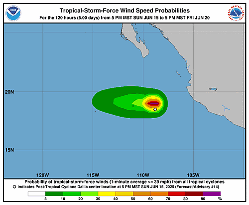
Wind Speed Probabilities last updated Mon, 16 Jun 2025 03:22:25 GMT ]]>


Tropical Sea Temperatures
Visit Weather Underground Tropical Weather Center